Go exploring. What’s the worst that could happen?
The worst that could happen? Assume that all of these places are dangerous and that you may die by falling down, hypothermia, drowning, falling rock, falling ice, falling into a crevasses, and getting eaten by wolves or mauled by sheep guardian dogs. Or, most likely, your driver goes off a cliff or hits another car head-on. Don’t say we didn’t warn you. This is not the Swiss Alps. There is no rescue team of mountain guides and doctors on standby with a helicopter.
A shepherd leads his flock over the snow on the Khanako Pass. Photo by the Lazarev 1988 expedition.
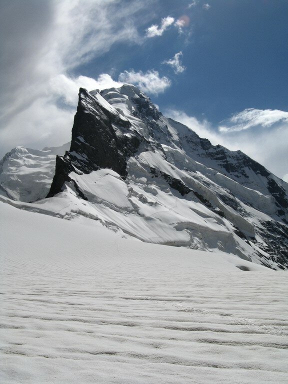
Photo of the Tuteklik Massif by the 2007 Vadim Kodysh expedition. Click here to see their other photos.
These destinations listed below are in addition to our suggested treks, many of which are very seldom visited areas for trekkers - or not at all.
Here are the places that, with rare exception, have little to no information available. Mostly all there is are incomplete shepherd trails mapped visually by satellite, uncertain river fords and the occasional Russian climber report (but they focus on the climb, less so on the trek leading to the climb).
Upper Zarafvshon
Demnora Glaciers
Dihandang River
Rogh River and Tuteklik Massif
Shakhisafed River
Khojai Muso Pass
Zeravshan Glacier
Yaghnob Valley
Zamin Qaror and Hosilot
Yaghnob to Arkhu to Shaukhan
Romit
Khanoko Pass into the Yaghnob headwaters
Navobod (Rasht) to Kaniz (Romit)
***
Upper Zafafshon
1. Demnora Glaciers
South Demonora Pass, the only trek-able pass in this area, looks unpleasant (rocky, ravines, nothing spectacular) based on the one Russian climbing team who passed through (they were not impressed). But the glaciers elsewhere in Demora river basin look quite interesting in the satellite view. To get there, drive from Langar to the village of Demnora and head south up the Demnora River (on the east side of the river; that’s the right bank, or looking up the river it’s the left-hand side.) Half-way up the river is a possible problem: a river ford. But the sheep trail eventually appears on the other side. So hopefully it’s an easy low-water crossing. Satellite view makes it look slow flowing at least. From here, head up the river until you get to the East Demnora Glacier and the Demnora Hanging Glacier. They look spectacular from the satellite view, but that doesn’t always equal a good view from the ground. I’m guessing it’s a two-night, three-day trek for a reasonably quick hiker to get up and down the river.
Google Maps link to glacier (enable satellite view)
2. Dihandang River
Possibly interesting glaciers, one with a small hanging section. Probably not that interesting earlier in the summer when the glaciers are still covered in snow. Drive from Langar up the river to Khudgif (Khudgiv) and cross the bridge to the foot path on the opposite bank. Or, drive further to the tiny hamlet of Pangpif (Pangpiv) and cross the bridge there. Continue on foot up the river, following the sheep trails until you come to the Dihandang River, a smaller side tributary of the Zeravshan River (there is a trail on only one side of the river, the west left bank side - on the right facing up-river). Eventually you will come to a large snow-bridge crossing. This looks like a big one - the type to be present every year and last for the entire summer. But… that can only be know by talking to the local shepherds. But it seems after the mid-point by the snow bridge you can choose either side of the river, as it’s open terrain. Eventually the trails fade and the ground gets rockier. But it’s open ground all the way to the glaciers. This looks like it could be done in a one-night, two-day trip if you have an early start, a driver and you are fast. But it’s best to plan for two nights, three days.
3. Rogh River and Tuteklik Massif
Russian climbers have provided some beautiful photos showing the glaciers and the Tuteklik Massif (see below). The approach on the Rogh River is shorter than other treks nearby (ie., from the Zeravshan River to the end of the trail and start of the glacier), but that means it will be steeper. Drive from Langar to the village of Rogh and start walking up the right side (left bank, west side) of the Rogh River. You will soon cross a foot bridge to the other side. Continue until a bridge that crosses the eastern tributary river and continue up the main Rogh River. Very soon another bridge appears and gives you two options: there are trails on either side of the river. I suggest choosing the west side (left bank, or the right side facing up-river). This goes the furthest and appears to offer the best angle view of the massif. The bottom of the glacier is debris covered (gravel, rocks, sand, silt, etc.) for a length of 4km until the blue ice appears. It’s safest to stay off the glacier. Be warned that the trail will be faded after the start of the glacier: the sheep trail disappears as you walk over hard, rocky ground.
Photo of a peak in the Tuteklik Massif by the 2007 Vadim Kodysh expedition. Click here to see their other photos.
4. Shakhisafed River
This is your chance to visit a very large, long debris-covered glacier with a big glacier cirque - without going all the way to the Zeravshan Glacier. You will also get to see what I think are oxidized iron mineral-rich streams that are bright red - bright enough to be seen on satellite. There are four of them, and you need to ford one of them. This riverside trail will be difficult, as I can’t say which snow bridge you should use to cross the river, and once you get to the glacier, you will need to navigate some steep moraines and very rough, steep mountainsides if you want to get further up the side of the glacier. Start you trip by driving from Langar to Pangpif and crossing the bridge. Go past the Dihandang River tributary (see #2 above) and then make a possibly dangerous ford crossing of the Nashpurt River (we have no idea how dangerous, but it seems the sheep are going across - it’s just not clear if they can only do it in the early morning and/or late in the summer, and how many of them drown). Once at the Shakhisafed river, start on the left bank, west side trail (on the right facing up-river). Then you can figure it out from there with multiple snow bridges marked further up river. How long is a round-trip from Langar? As many as four nights. But we don’t really know. There is no real info (and no photos).
5. Khojai Muso Pass
This is the pass you can go through as a trekker who wants to go from the far Upper Zarafshon Valley to the Rasht Valley, or the reverse (Langar to Navobod/Gharm). Khojai Muso Pass is used by shepherds from the Zeravshan side to graze their flocks on the south side of the mountain range, towards the Rasht Valley. However, the trek seems very difficult due to multiple river crossings (based on at least one Russian climbing report), a possible encounter with the border guard post in the Upper Zeravshan, and the fact that on the south side of the pass there is nothing but an empty mining road that you will hike on for a full day before you come to a village (not a problem if you start on the Rasht Valley side, as you can find a driver to drop you off). Also, after the last shepherd camp on the southside of the pass the trail fades completely, and you likely have to scramble slowly over boulders and through high vegetation to get to the road, where you will be greeted by a mining operation, but no villages and no drivers (it will be a long walk on a road with numerous fords meant for strong vehicles, not pedestrians).
In sum? Don’t do unless you really know what you are doing and are ready for unpredictability and scary river crossings. As for the pass, on satellite view you can see a sheep trail through the early summer snow in the pass. So it may be trekkable as early as June. How long will this all take? Maybe a week? Who knows… Send us a report if you go.
6. Zarafshon Glacier
At the top of the Zeravshan Valley is the massive Zarafshon Glacier. But look at the Google Earth view: it’s a massively long debris-covered glacier for quite a ways. Don’t expect to see any blue ice, just lots of rock. Check out these photos by Tajik scientists to get an idea of what it looks like at the terminus. But perhaps you can hike up a ridge to get a view of the upper glacier. For the quickest route, you need to drive from Langar (or a lower point in the Zeravshan Valley) past the last village on the main road (Dehisor). But your experience may depend on what side of the Zeravshan River you approach. If you stick to the main road on the right bank (north side), you will have to go through a border post after the final village of Dehisor. They will ask you where you are going, and be curious if you have plans to trek/climb into Kyrgyzstan. With all of these obscure frontier posts, your experience may vary. A real or not-real permit may be required. They may not let you continue. And if they do, there is a scary cable-car crossing, and I’m not sure who is in charge of access. If you approach from the other bank of the Zeravshan River, the border guards may spot you from their side of the river and determine that you are not a local shepherd - they may then come across to have a chat with you. You should probably contact the Zerafshan Valley Tourism Association and arrange a driver and guide through them. They will be able to handle the difficult stuff for you. But still, some scary river crossings remain…
Photos below from the 2015 Novoselov expedition to the Zeravshan Glacier. As a trekker you won’t be able to access those last two locations. They provide GPS tracks at this link. Useful for seeing where they forded the rivers, but don’t follow the GPS track onto the glacier and mountaineering portion of their journey.
Yaghnob Valley
1. Zamin Qaror and Hosilot
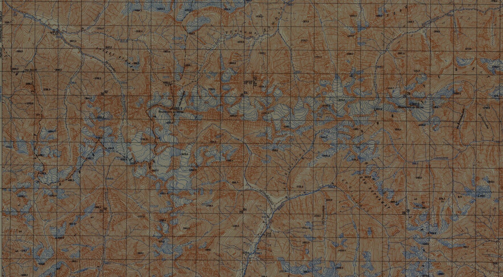
This is really not very difficult in terms of distance and time-commitment, it’s an overnight trip from the guesthouses in the village of Margheb in the lower Yaghnob Valley (or you can go onward up the Yaghnob Valley). The Zamin Qaror massif looms over the village of Margheb and is occasionally visited by Russian rock climbers who scale its impressive cliffs (check out this Youtube video). But there are no approaches safe for a trekker to the glacier that straddles the middle of the massif. However, you can hike further behind Zamin Qaror to the Hosilot Glacier below Hosilot Peak. There appears to be a goat-trail from the west, but it may be a dangerous scramble or climb for a person. The eastern approach is not mapped, but based on the topography and satellite view, it seems OK. To access the eastern approach, you will need to go loop behind Hosilot Peak via the Tagrich Pass. There is a pass listed on the map right next to the Hosilot Glacier (Glacial/Ледовый Pass) that has a 2A rating. Based on the terrain, I don’t see how it could be this difficult. Perhaps this difficulty refers to a route that follows the very steep river gorge rather than the goat-trail approach, or maybe the glacier was bigger in the past. No reports are available.
After visiting the glacier, you can head back to Margheb, or towards the Yaghnob River upstream form Margheb. The most predictable route is through the Varsaut Pass, and the adventurous option is to go straight down the Mushtif River through the canyon/gorge straight to the Yaghnob River. There’s a trail next to the Mushtif River on the old Soviet topography maps, but that doesn’t always mean it’s safe or hike-able. For the extra adventurous, look at the satellite view of Hosilot Glacier, going north from there you can see a talus/scree slop that looks like it might go right to the top of the Zamin Qaror ridge. If you get to the top you might be able to peak over the cliff at the Zamin Qaror glacier. Send us a report if you are successful in doing that. But you should probably not try, as it may be too dangerous.
Note: when you leave the village of Margheb towards Tagrich Pass you will be going on a new mining road, and passing by a mine. It’s not mapped yet, but we will add it once we get a GPS track or a new satellite imagery update.
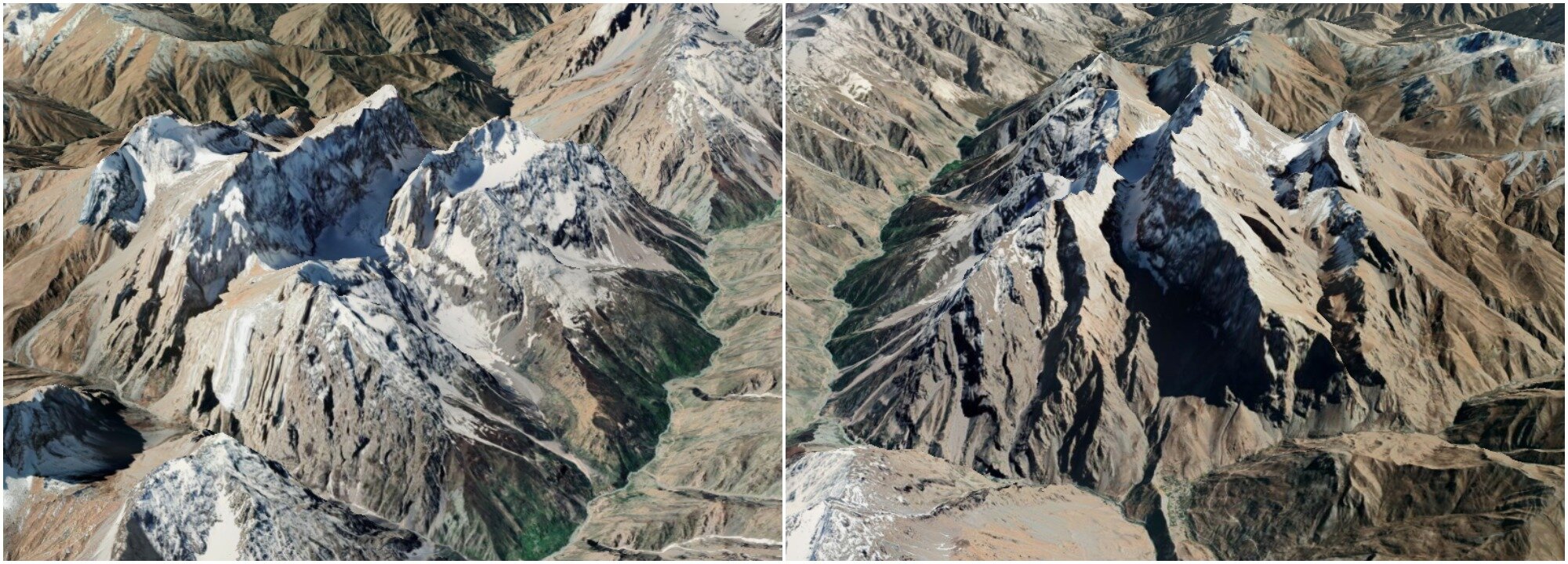
The image below is a 3D Google Earth rendering of the Zamin Qaror massif from the west (left image) and east (right image). In the right-side image, the tiny green patch at center-bottom is the village of Margheb.

2. Yaghnob to Shaukhan to Arkhu (Romit)
The Shaukhan River flows into the Tagobikul River, a tributary river to the Yaghnob River; the Arkhu River is on the other side of the mountains and it drains to the Sardai Miyona and then past Romit. In between is a ridge that does not look difficult, and some interesting-looking glacier in the upper Arkhu River. However, there are no shepherd passes or passes across this ridge used by mountain climbers. You will need to study contour maps and satellite images to pick your own route. And there are no guarantees that it would be safe. For now, all I can say is that there are shepherd trails going up the Arkhu River, and up the Shaukhan River.
Romit
1. Khanoko Pass into the Yaghnob headwaters
From Romit you can drive up the Sorbo River to the tributary Khanako River, not to be confused with the Khanaka River in the western Hisor mountain range. There is a shepherd’s trail along the Khanako River, but it’s not completely clear when to cross the river and what side to stay on (there are several bridges and snow bridges). If you go all the way up the river, you can cross through the Subashi (or Eastern Khanako) Pass, down a gentle glacier and into the Yaghnob River basin.
From here you are already east of the Sangdara River (good news as you can’t cross it safely), and if you trek down the right bank of the Little Barzangi River you are in good shape to head over an easy pass, Akbali-2 Pass, and down to the extreme upper Yaghnob River, which you can cross. Then you only need to deal with crossing the Takali River (by going up to a snow bridge and then back down), and you will be on the trail that takes you down the Yaghnob Valley.
2. Navobod (Rasht) to Kaniz (Romit)
Starting in the town of Navobod in the Rasht Valley, take a taxi to the village of Duoba, or even better to the final hamlet past Duoba where the road ends. From here you go up the Duoba River and then up a ridge. Eventually the trail fades as there is no grass left for the sheep tograze. You move over open terrain (but likely rough and rocky) through a saddle with an unnamed pass. From here, go down the Obisafed River and then west up a tributary. You are now trying to get up on a ridge and traverse Shodmoni Pass and onward to Zorkamar Pass. There are no glaciers you need to cross, but there may be a cornice blocking you from easily getting onto the ridge leading to Shodmoni Pass. Once near Zorkamar Pass you will see well established sheep trails that go back down to the Rasht Valley, or the opposite direction to the Kaniz/Sorbo River and Romit. At this point you can just start to follow the instruction in in our suggested Mujikharf-Romit route.
*****
That’s it for our list of little-known places to explore. And by “explore,“ we mean visit a place that shepherds have gone for the last 3000 years. If you do go, send us a report and a GPS track for those spots where the trail is not on the map. And if you haven’t seen them, check out our list of suggested treks.


