Bartang to Murghob High Route
Bartang to Murghob High Route
This is the only high route listed on this website that can be done in (late) spring. It can also be done in the fall, with a warning that peak glacier melt in July and August mean very high and possibly impassable rivers. I would avoid this route in the summer.
Start: Village of Ghudara in the upper Bartang Valley. The last village.
End: Murghob (Murgab) on the Pamir Highway.
Highest point: 4773 Meters (Eastern Depshe Pass)
Lowest elevation: 3102 Meters (Bartang Valley)
This high route has already been done. The group, led by Sergei Vinokurov, travelled west-to-east from late May to mid-June over 18 days.
Vinokurov group GPS tracks: Download GPX; Download KML (Google)
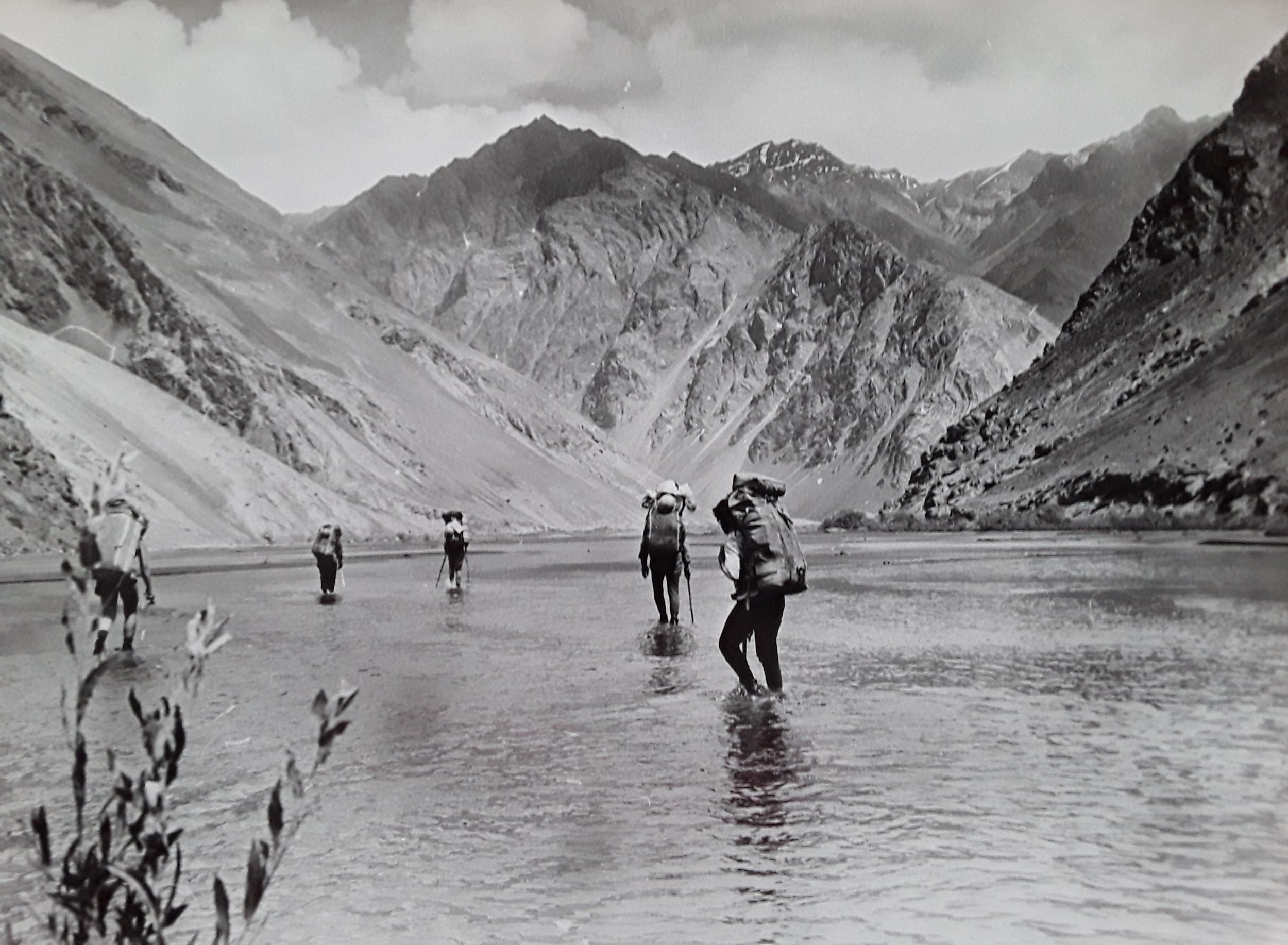
Photos below by the Vinokurov group:


The Vinokurov group’s trip is well documented here: Part 1, Part 2, Part 3, Part 4, Part 5, Part 6 (use Google translate).
Important points made by Vinokurov:
Relatively good weather. Average rainfall in this area in May is 13 mm, Average monthly air temperature in May: 7°С.
The group took crampons, but no other special equipment (e.g., no ice axe, no ropes, etc.)
Possibility of snow in the high altitude part of the trek.
May-June have long daylight hours.
Snowmelt provided much of the drinking water that may not be present in summer or fall.
In May-June the glaciers are not melting too much yet, so the crossings are not difficult.
Vinokurov estimated his weight loss at 15kg over 18 days. If you do not have enough fat to burn through 1kg per day over 18 days, then very carefully plan your very heavy food carry.
Nobody else seen anywhere on route until close to Murghob (minus the chance meeting with locals dispatched to check out a fire).
My comments on the Vinokurov route
It’s hard to find a better planned route than that done by Sergei Vinokurov. He did his research into previous expeditions in the same area, he researched weather/climate/altitude, logistics, old maps, random information from the internet, he consulted with locals ahead of time, etcetera… I do not have much to add.
Regarding the distance travelled, if you subtract the group’s side trip and the extra distance before Ghudara, the distance of the route is about 180km.
If you look at Vinokurov’s GPS track on your map app, note that the group did not start their track in Ghudara as planned, but rather 5km down the Bartang River due to a car/driver problem. So you don’t need to start where they did, but rather in Ghudara.
Travelling west-to-east you will come across an old landslide blockage on the Western Pashart River, just upriver from the confluence with the Murghob River. Vinokurov went climbing up through the boulders next to the river/cascade. Afterwards he noticed the easy bypass up high on the hillside. Make sure to take the easy upper route.
Acclimatization hike: In the western part of the GPS track above you can see a side trip to the south, up and back down the Timurkuljilga gorge (Timurkul = Timur Lake, and jilga = dry gorge or a gorge with an intermittent stream/river). This was done as an acclimatization hike. An acclimatization hike is a very good idea, but this gorge does not seem worth the trip based on the Vinokurov photos. For an acclimatization hike, I suggest the nearby Khafrazdara trek that starts and ends in the village of Pasor, about 10km south of Ghudara. You can find full instructions on the Adventures of Nicole blog. The alternative is to go very slowly up the Azintosh gorge towards Expedition Pass.
My personal preference for an acclimatization hike would be in Jizevdara, or the Jizev gorge. It makes sense for your to be coming from the town of Rushon if you are trying to find local transportation. And very close and easy to reach is the trek up and down the Jizev gorge. You can stay at a guesthouse in the gorge and do an acclimatization hike to the top of the gorge (up a ridge, along a glacier, whatever) and spend a night at elevation in a tent before returning to a guesthouse. Of course, in this scenario you would have to return to Rushon to find transportation up the Bartang river. Another option that removes the need for transportation is an acclimatization hike directly from Rushon. You can hike up the Vomardara gorge and then up the Odudi gorge, then return to Rushon.
Start date: The Vinokurov group started on May 24th. This start date, however, may involve some travel on snow. In some years, the last week of May still has snow up on Expedition Pass and Eastern Depshe Pass. I would not start earlier than the Vinokurov group did, and I would make sure to not be anywhere on this route in July or August due to high water levels in the rivers. So you should start between the last week of May and mid-June. As for travel in the fall, you will have to take into account the drier terrain (possible heavy water carries) and be worrying about the first snowfall.
Direction of travel: For acclimatization, west-to-east is better. For arriving in a location with accommodation and transportation easy to find, west-to-east is better. The opposite direction is possible, but you will arrive in the far upper Bartang in a tiny village. You may have to walk a long way down the Bartang to find transportation and a food store.
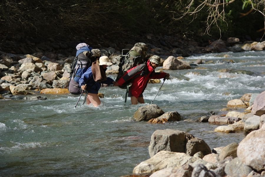
River crossings: Read the Vinokurov report. And look at the GPS track over a satellite imagery map. It looks like 24 crossings of the West Pshart River. Another climbing group who also went up and down the West Pshart River reported about 20 crossings (to avoid cliffs or dense brush). But, as Vinokurov writes, “Everywhere is shallow, maximum knee-deep, the current is calm.“ But that may not be the case in July and August during times of maximum snow melt. January 2023 update: The Romanenkov group walked down the West Pshart River on August 3, 2022. It is still safe and easy to cross in mid-summer.
I don’t plan anything special for the river crossings, aside from a dedicated pair of river crossing shoes.
The seasonal river warning, based on a couple of anecdotes, more so applies to the Kokuybel River than the Western Pshart River. The Savchinsky climbing group travelled along the West Pshart River on August 20, 2011, and crossed more than 20 times. the water levels don’t look so bad (photo via Savchinsky 2011):
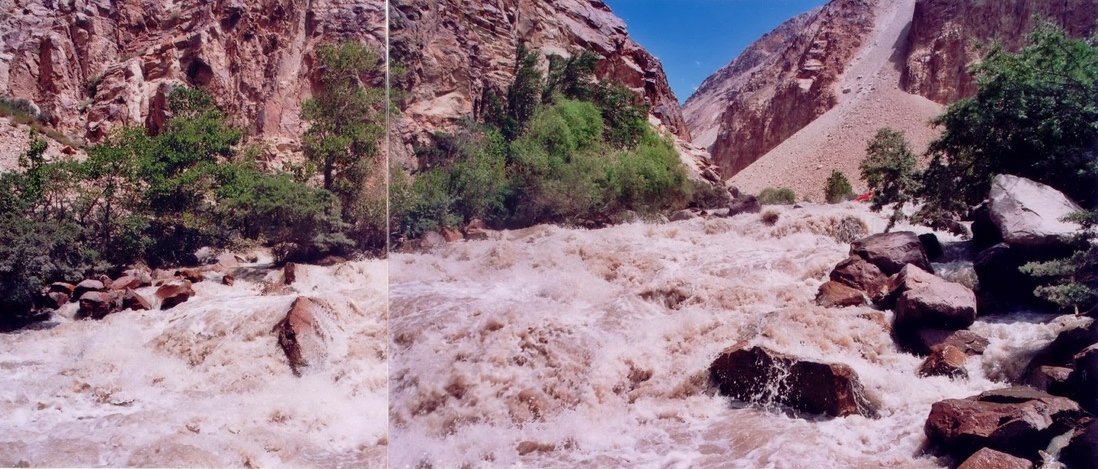
Note that the easy crossings of the West Pshart River only apply to the upper reaches. You will need to do one challenging crossing of the West Pshart right above where it flows into the Murghob River. The first photo below is on August 3, 2022 by the Romanenkov group and the next photo below is by the Vinokurov group on June 7, 2011 (in a different location, likely farther upriver), showing an easier crossing in early summer.
Kokuybel River: I’m not sure that the Kokuybel River keeps its (Kyrgyz) name as it gets closer to (the Pamiri village) Ghudara. But I will keep using that name until I find out otherwise. 2023 update: The locals in Ghudara do recognize the name Kokuybel, but their name for the river is Yurik (I’ve made the change in Open Street Map).
Questions about how high the water level gets in the peak of summer water levels is addressed by Vinokurov referring to the Sazonov expedition of 1988. It’s not a good time for a hike in the Kokuybel Gorge. But if you want some visuals (the Sazonov photos are poor quality scans), then we can consult with the group that went down the river in catamarans, the Chernik expedition of 2005 who went down the Kokuybel River in mid-August:
Escape Routes: There is only one exit from this high route, and that is between Expedition Pass and Eastern Depshe Pass where you have the option to go north and down to the upper Kokuybel River, where you should find shepherds, eventually, and a road.
Horses/donkeys: Once you arrive at the West Pshart Hydrometerological Station the rest of the journey to the town of Murghob is easy enough for a horse or donkey, as you can see in this Twitter thread (check it out for the photos).
Permits required: (1) The GBAO permit is required to visit the region as a whole, and (2) A Tajikistan National Park Permit. Officially, you need to pay a fee to be in the Tajikistan National Park (formerly known as the Pamir or Badakhshan National Park). This is payable to the forest rangers (forest ranger in Tajik: Jangalbon; Russian: Lesnik) if and when you meet them (about $10 per day). You do not need to pay this fee ahead of time (unless, of course, you meet a ranger at a trailhead). In some areas, they collect fees 100% of the time, and in other areas they never do. To be clear, you do not need to secure permission or pay a fee ahead of time. It seems that the rangers would actually prefer you wait and pay them directly instead of paying at their head office (as far as I know, it’s only possible to easily advance pay at the PECTA Office in Khorugh).
Some Russian climbing groups have had a tour company purchase their permits ahead of time in Dushanbe (where and how, I do not know), but when they met the rangers at the trailheads the rangers said their Dushanbe-purchased permits were not valid, and that they need to pay the ranger directly. So I prefer to wait until—and if—I meet a ranger to pay for the permit. I have never heard any story of a forest ranger turning someone back, denying them entry, or fining them.
The Vinokurov group did not encounter a ranger in Ghudara in 2011, so they did not need to pay the fee. In 2024 the national park fee was raised from $2 to $10. Anecdotally, the fee increase has incentivized rangers to be more thorough in collecting fees. Ghudara has always been a fee collection point - but focused on cyclists and drivers using the road, not the Yurik gorge. If the Vinokurov trio had instead gone in 2024 and stated to the ranger that they plan an 18-day trip, the ranger’s initial ask would have been $540.
Sarez Lake Permit? This route includes a side trip down to Sarez Lake, and you will be near the inflow to Sarez Lake on the east side of the lake. Officially, to visit Lake Sarez you must pay a $50 per day fee ahead of time and show proof of medical insurance. This however, can really only be enforced at the west end of the lake, at and above the village of Barchidiv - on the west end of the lake at the Ministry of Emergency Situations monitoring station on top of the natural landslide dam. Basically, in practice, the fee is to visit the dam or to pass through that area. None of the groups that have visited other parts of the lake mentioned paying a fee.
Abandoned “West Pshart” Hydro-Meteorological Station: Nobody has been working at the station here for decades. It has been looted, but it is just too isolated to carry away the heavier or less valuable material. So it remains as an open-air museum. You can see the photos in Vinokurov’s report - direct link. The Vinokurov group met nobody along the entire length of their trek, but near this station they met a mixed group of government workers and friendly security officers. This sort of meeting is highly unlikely. This group was there because of a satellite alert for a brush fire (which the Vinokurov group had seen) and this group was sent to check it out. Note that no mention was made of a permit when the two groups met.
Backpacks: If you are used to short trips or ultralight gear, you may want to consider a new backpack that is designed for heavy carries. If you take as long as the Vinokurov group, that will be 18 days worth of food in your bag. The backpacks that the Vinokurov group wore are definitely in the old-school “traditional“ category in terms of size (at least one of them has what seems to be a 120 liter bag). What can you get away with? Not ultralight, but certainly something lighter and smaller. My bag has about 80 liters of capacity, and I think I can fit what I need in that. It’s possible that you may be faster than the Vinokurov group if you have a much lighter bag on your back.
Vinokurov side trips: As mentioned above, I don’t plan to do the same side trip to the Timurkuljilga gorge as did the Vinokurov group. And I plan to skip the route through Qarobuloq Pass, Jilgakul Lake and Depshe Pass. The lake appears to be an underwhelming livestock pond that is not worthy of doing the two extra passes. I plan to — after visiting Sarez Lake — to go back up the gorge and then east up the Depshe Gorge straight to Eastern Depshe Pass, skipping the side trip to Jilgakul Lake.
My planned side trips: When descending the Kazankul Gorge I plan to hike up the ridge to the south to get a high vantage viewpoint of Sarez Lake. In the eastern section along the Western Pshart River I plan to take a side trip up the Sauksoy Gorge to get a view of the Muzkol mountains (if I’m there in the fall, late spring to early summer may be too snowy still). What do the Muzkol mountains look like at the head of the Sauksoy Gorge? See the photos below via the 2016 Ulyanov climbing expedition:
Murghob River (Murgab): Looking at the map you may wonder why the Vinokurov group did not follow the Murghob River all the way from Sarez Lake to the town of Murghob. Vinokurov did his research. He knew it was not a good idea to try to follow the gorge all the way (instead of turning up the West Pshart River tributary). You can see how rough and impassable the gorge is in photos by boaters who went down by kayak or catamaran. See, for reference, photos by Chernik 2005, Soprunov 1990, Brynin et al 1986, and Babintsev 2018.
There is a very narrow and rough section of the Murghob River betwenn 3400 meters and 3500 meters. But above this is very gentle, as can be seen in photo by L.A. Fedorovsky.
Additional Reports: If you can read Russian, you can consult a few additional reports from expeditions who covered some of the same ground.
Sazonov 1988 - Western Pshart Valley, GMS Pass, Eastern Depshe Pass, Expedition Pass and Kokuybel Gorge.
Savchinsky 2011 - Eastern Depshe Pass and Sarez Lake.
Romanenkov 2022: Technical report and a photo essay. The climbing group went down the West Pshart River from the confluence with the Sauksoy River until the Hydro-Meteorological Station on the Murghob River.
Can’t find the place names on your map? Then switch to OsmAnd.
Last updated: January 2025


